09 October 2015
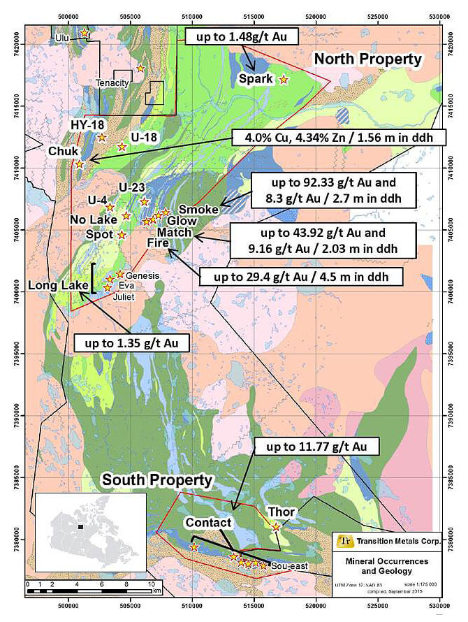
Sudbury, October 8, 2015 – Transition Metals Corp. (XTM – TSX.V) (“Transition”, “the Company”) and Nunavut Resources Corp. (NRC), in their capacity as partners in an alliance (“the Alliance”) are pleased to announce that new airborne geophysical data and compilation work has highlighted several high potential gold and base metal target areas within the north portion of Inuit Owned Land parcel IOL CO-20 otherwise referred to as the “North Property” depicted in Figure 1. IOL CO-20 is located along the Izok Corridor, an infrastructure initiative proposed by MMG Ltd. consisting of a 325 kilometre road to a port facility in Grays Bay. Grays Bay is located on the shore of the Coronation Gulf approximately 175 kilometres southwest of Cambridge Bay, Nunavut.
Work completed by the Alliance on the property to date includes the digital compilation of historical exploration data and the completion of a 275 line kilometre airborne EM and magnetic survey over the Fire-Shear area utilizing the Geotech Ltd’s VTEM system in August 2015. The results of this survey highlighted a number of high priority gold and base metals targets that are discussed in more detail below.
Commenting on the results of this work, company CEO and President, Scott McLean said: “The Alliance with NRC continues to identify excellent exploration opportunities that continue to demonstrate why Nunavut is an excellent frontier region to explore. At a time when exploration activity in the north is at a low, the Alliance is positioning itself for success by adding value to its projects with excellent support from the Kitikmeot Inuit Association (KIA). The Alliance together with the KIA have a sustained approach and vision for the north that continues to highlight the mineral potential of the region by identifying new exploration opportunities with an objective of attracting new investment to Nunavut”
Charlie Evalik, President & Chair of NRC commented, “We continue to be pleased with the good work that the Alliance is executing for the benefit of Inuit. We are also extremely appreciative of the ongoing support provided by our shareholder, the Kitikmeot Inuit Association. Their commitment to the vision of NRC as the only active 100% Inuit-owned exploration business is exemplary and we are confident that their assistance will be ultimately rewarded”.
2015 Summer Program Highlights
¹ Assessment Report AR083359 - MacMaster, G. 1994; Drilling Report on the PULSE 3, 4, 5, 6, and KINDLE 4, 5, 6 Claims; Northern Mining District, BHP Minerals Canada Ltd.
² Johnson, W. and Robinson, P. 1975. Report on Field Work in the Hood River – Kathawachaga Lake Area, Northwest Territories for the 1975 Field Season; Long Lac Mineral Exploration Ltd. Assessment Report AR061408, 55p. with maps
About the CO-20 Property
In 2014, the Alliance entered into a Mineral Exploration Agreement (MEA) WestKit-0001 agreement with Nunavut Tunngavik Inc. (NTI) covering two areas within IOL CO-20, an Inuit owned mining rights area covering a number of prominent gold and base metal showings.
The North Property covers approximately 21,154 ha extending from the north shore of the Hood River adjacent to the southern boundary of WPC Resources’ Ulu and Hood River properties that host the Ulu Deposit which has published resources of: 605,000 Oz of Measured and Indicated Resources grading 7.53 grams per tonne (g/t) gold and a total of 226,000 Oz of Inferred Resources grading 5.57 g/t gold. ³ The best mineralization identified to date on the Alliance property is located at the Fire-Shear and Contact gold showings areas, and the Chuk copper-zinc showing areas. Of these areas, only portions of the Fire-Shear area was covered by the 2015 airborne survey discussed above.
³ Technical Report on the Ulu Gold Property, Nunavut Canada; July 10, 2015, Cowley, Singh and Giroux – www.sedar.com
The South Property covers a 5,186 ha area located south of the Hood River hosting a number of mineralized showings. The Contact showing located on the South Property hosts six significant gold showings with showings 1, 2, 3, 5 and 6 covering a 3 km west- northwest-trend and showing 4 located an additional 3 km to the northwest. Showing 1 returned up to 19.2 g/t of Iron formation hosted Au in grab samples while showings 2, 5, and 6 returned up to 2.1 g/t over 1.7 m, up to 1.2 g/t Au, and up to 2.8 g/t gold over a 3 by 3 m area of felsenmeer respectively4. The Chuk showing in the North Property, is interpreted from limited diamond drilling to be prospective for hosting volcanogenic polymetallic base metals sulphides. The Chuk showing area has only two recorded diamond drill holes totaling 151 m, that intersected 1.56 m of massive sulphide zone which returned 4.0% Cu and 4.34% Zn and 3.56 metres of stringer sulphide which returned 0.031 Oz/ton Au, 2.23% Cu and 2.1% Zn. ⁵
⁴ Osatenko, M.J. 1986. Assessment Report, Geological Mapping, Rock Sampling and Magnetic/HLEM Surveys on the Hood Property. Mackenzie M.D., N.W.T. Cominco Ltd., Assessment Report AR082096 23p., with maps.
⁵ Anderson R. and Bryan D. 1980. Geological and Geophysical Surveys and Diamond Drilling. District of Mackenzie, N.W.T. Noranda Exploration Company Ltd.Assessment Report AR081532 filed NTI 9p
Qualified Person
The technical elements of this press release have been reviewed and approved by Mr. Greg Collins, P.Geo. (APGO), a Qualified Person as defined under National Instrument 43-101.
About the NRC Alliance
The NRC Alliance is a five year strategic alliance entered into by Transition Metals Corp., and Nunavut Resources Corp. in 2012 to conduct project generation and exploration work in the Kitikmeot region of Nunavut, Canada. The two companies work together to identify exploration properties with the objective of forming Joint Venture partnerships to attract investment and to facilitate work leading to the discovery of economic ore deposits and ultimately the development of new mines and infrastructure in the region. The Alliance maintains a highly prospective exploration portfolio consisting of 123,770 ha of gold, base metal and diamond properties in Nunavut and NWT which include Itchen Lake (banded iron formation hosted gold), CO-82 - Gondor (VMS potential surrounding MMG’s Gondor Lake deposit), CO-31 - Arcadia Bay (high grade lode gold vein system), C0-30 - Anialik (high potential greenfield gold and base metals), CO-20 - Fire Shear (high potential greenfield gold project close to the Ulu project) and Article 41, a 572 square kilometer diamond project situated between the Jericho and Lac de Gras diamond fields.
About Transition Metals Corp
Transition Metals Corp (XTM -TSX.V) is a Canadian-based, multi-commodity project generator that specializes in converting new exploration ideas into Canadian discoveries. The award-winning team of geoscientists has extensive exploration experience in established, emerging and historic mining camps, and actively develops and tests new ideas for discovering mineralization in places that others have not looked, which often allows the company to acquire properties inexpensively. The team is rigorous in its fieldwork, and combines traditional techniques with newer ones to help unearth compelling prospects and drill targets. Transition uses the project generator business model to acquire and advance multiple exploration projects simultaneously, thereby maximizing shareholder exposure to discovery and capital gain. Joint venture partners earn an interest in the projects by funding a portion of higher-risk drilling and exploration, allowing Transition to conserve capital and minimize shareholder’s equity dilution. The company has an expanding portfolio that currently includes 26 gold, copper, nickel and platinum projects primarily in Ontario, Nunavut and Saskatchewan.
About Nunavut Resources Corp
Nunavut Resources Corporation, a wholly-owned subsidiary of the Kitikmeot Inuit Association, was established to participate directly in a) the development of the minerals, oil and gas for the benefit of Inuit, through ownership of resource projects and b) infrastructure essential to resource development, all in a transparent manner consistent with Inuit values. NRC aims to enter into economic partnerships with resource companies to advance its mandate. One such partnership is its Strategic Alliance with HTX Minerals Corp (a wholly owned subsidiary of Transition Metals Corp), which is serving to advance NRC’s regional mineral exploration programs.
Cautionary Note on Forward-Looking Information
Except for statements of historical fact contained herein, the information in this news release constitutes “forward-looking information” within the meaning of Canadian securities law. Such forward-looking information may be identified by words such as “plans”, “proposes”, “estimates”, “intends”, “expects”, “believes”, “may”, “will” and include without limitation, statements regarding estimated capital and operating costs, expected production timeline, benefits of updated development plans, foreign exchange assumptions and regulatory approvals. There can be no assurance that such statements will prove to be accurate; actual results and future events could differ materially from such statements. Factors that could cause actual results to differ materially include, among others, metal prices, competition, risks inherent in the mining industry, and regulatory risks. Most of these factors are outside the control of the Company. Investors are cautioned not to put undue reliance on forward-looking information. Except as otherwise required by applicable securities statutes or regulation, the Company expressly disclaims any intent or obligation to update publicly forward-looking information, whether as a result of new information, future events or otherwise.
Neither the TSX Venture Exchange nor its Regulation Services Provider (as that term is defined in the policies of the TSX Venture Exchange) accepts responsibility for the adequacy or accuracy of this release.
Further information is available at www.transitionmetalscorp.com or by contacting:
Scott McLean
President and CEO
Transition Metals Corp.
Tel: (705) 669-0590
Figure 1: Geology and Showings of the CO-20 Property based on historical data